Journal and photos for Section N posted
A summary of the trek is available as web page and printable PDF
Southland Times news story April 10 "Man Walks NZ to Clear Mind" (PDF)
Epilogue posted April 21
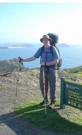
The start at Cape Reinga October 15
|
|
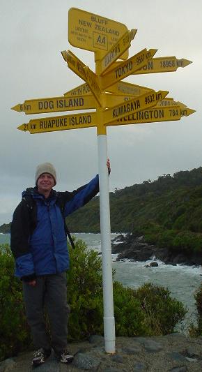
Update April 10, 2004 from Invercargill: the entire 1600-mile trek was completed at Stirling Point, Bluff, on April 8, 2004 at 5:00pm! Journal and photos for Section N posted A summary of the trek is available as web page and printable PDF Southland Times news story April 10 "Man Walks NZ to Clear Mind" (PDF) Epilogue posted April 21 |
The start at Cape Reinga October 15 |
Eric Martinot took a sabbatical to hike the length of New Zealand continuously from north to south -- starting at Cape Reinga at the top of North Island and finishing at Bluff at the bottom of South Island. The route was about 2600 km (1550 miles), and took from October 15, 2003 to April 8, 2004. This period included roughly 95 hiking days (typically 15-25 km/day for more difficult trails and 30-40 km/day for easier trails and roads), 20-25 days spent updating this web site enroute, 15-20 days for professional work, and 35 rest/bad-weather days.
|
The route combined forest/mountain trails, beach walks, dirt roads, paved roads, other recreational walkways, and a few off-trail segments. With just a few exceptions, the route is entirely on public land. Although there is no continuous trail yet, the Te Araroa Trust is committed to making a continuous trail a reality (called Te Araroa, which in Maori means "the long trail"). The trek route followed the emerging Te Araroa route to the extent possible, given other considerations discussed in the journal pages below (the main diversions were from Auckland to the Wanganui River, from Cape Farewell to St. Arnaud, and from Arthurs Pass to Twizel). The route is divided into 14 sections of roughly 100-260 km each. Typically, each section's start and end represent resupply points, similar to the way sections are used on the Pacific Crest Trail. The table below links to photos, journals, and route data/details for each section.
Email related to the trek can be addressed to
nztrek@martinot.info. |
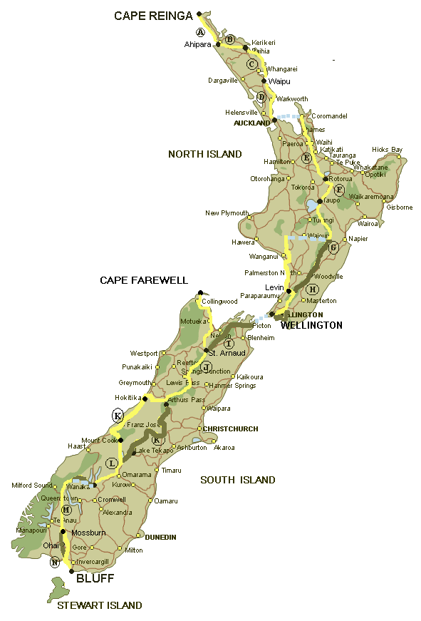 |
| Section | Start/end | Distance | Hiking days | Dates hiked |
| Auckland to Cape Reinga (via bus) | ||||
| Section A | Cape Reinga to Ahipara | 110 km | 4 | Oct 15-19 |
| Section B | Ahipara to Kerikeri | 120 km | 4 | Oct 21-24 |
| Section C | Kerikeri to Waipu | 160 km | 6.5 | Oct 28-Nov 3 |
| Section D | Waipu to Auckland | 130 km | 4.5 | Nov 6-10 |
| Section E | Auckland to Rotorua | 260 km | 10.5 | Nov 18-Dec 4 |
| Section F | Rotorua to Taupo | 80 km (*) | 0 | Dec 5 |
| Section G | Taupo to Levin | 320 km | 12.5 | Dec 12-29 |
| Section H | Levin to Wellington | 140 km | 7 | Jan 1-12 |
| Wellington to Cape Farewell (via ferry/bus) | ||||
| Section I | Cape Farewell to St. Arnaud | 230 km | 7.5 | Jan 21-31 |
| Section J-1 | St. Arnaud to Lewis Pass/Boyle | 140 km | 6.5 | Feb 3-10 |
| Section J-2 | Lewis Pass/Windy Pt. to Arthurs Pass/Aickens | 80 km | 4 | Mar 27-30 |
| Section K | Arthurs Pass/Aickens to Mt. Cook | 280 km (**) | 9.5 | Feb 14-Mar 1 |
| Section L | Mt. Cook to Wanaka | 180 km (*) | 4.5 | Mar 2-7 |
| Section M | Wanaka to Mossburn | 210 km (**) | 6.5 | Mar 13-20 |
| Section N | Mossburn to Bluff | 160 km | 5 | Apr 2-8 |
| Invercargill to Auckland (via bus/train) | ||||
| Epilogue | Final thoughts, tramping safety, Tongariro/Waikato sections |
North Island Summary
From October 15, 2003 to January 12, 2004, I trekked the entire length of New Zealand's North Island along a 1330-km route by walking 1240 km, bicycling 80 km, and kayaking 10 km.
The route was continuous (i.e., "every step of the way") with two exceptions: (1) there were seven motorized (car or boat) water crossings of 0.1 to 4 km each, necessary to cross rivers or harbors along coastal portions of the route where no bridges exist or where walking is otherwise impossible (Wellington Harbor was 10 km). (2) My route shifted about 80-km to the east of the Te Araroa route from Auckland to Pipiriki (see map). The shift allowed me to walk through the Cormandel, Kaimai-Mamaku, and Kaweka forest parks and avoid substantial highway walking. The shifts were done by car, first 80-km to the east from Auckland to Coroglen, and then back 80-km to the west from Kuripapango to Pipiriki, and were done at constant latitude to preserve north-to-south continuity.
The trek required 49 hiking days (an average of 25 km per day) and 1 bicycling day. During this period, there were also 29 "rest" days (including the time to update this web site), 6 "work" days (professional work on the computer), and 2 days attributed to letting an injured foot heal. The number of rest days was much higher than anticipated, because: (1) my last day at work was October 8, and the next day I flew to New Zealand, meaning that the early stages of the trek were also a recovery from the intense activity of completing professional obligations and preparing the trek before I started; (2) the time to update the web site was considerable; and (3) I waited for weather to clear in a few spots where river crossings or alpine routes were impassable in bad weather.
North Island Awards
Favorite part overall: 90-Mile Beach (Section A)
Favorite forest park: Kaweka (Section G)
Favorite North Island district: Far North (Sections A/B)
Favorite town: Kerikeri (Section B)
Favorite cafe: Kamaril Cafe, Waipu (Section C)
Favorite hut: Waitewaewae Hut, Tararuas (Section H)
Deserving of special mention: North Shore City's East Coast Bays Walk (Section D)
Most challenging tramping: Tararua mountains (Section H)
Most energetic, strongest, "dialed" tramping day: Day 1 of Tararua "southern crossing" (Jan. 10)
Most vertical ascent in a single day: Day 1 of Tararua "southern crossing" (1700 meters)
Highest elevation reached: Kaweka J, at 1724 meters (Section G)
Most historic point: Waitangi Treaty House (Section C)
Most isolated part: Kaimai-Mamaku park (Section E)
Most unpleasant part: extensive highway/road walking from Matakana to Browns Bay (Section D)
Most dangerous part: rocky face above ridgetop gully near Puketoro Knob in Tararuas (Section H)
Most dangerous, runner-up: one crossing of Waitawheta River in Kaimai-Mamaku (Section E)
South Island Summary
From January 21 to April 8, I walked 1250 km in 44 hiking days (average daily distance of 28 km), and also bicycled 30 km, to trek a continuous (unbroken) 1280-km route from Cape Farewell to Bluff, with three exceptions: (1) a 10-km "jump" over Copeland Pass that would otherwise require moutaineering skills, in Section K; (2) a missed 8-km of highway walking at Lewis Pass, from Boyle to Windy Point, between Sections J-1 and J2, due to transport logistics and a group start of Section J-2; and (3) a 80-km shift from Wanaka due-west to near Dart Hut in Section M, in order to bypass rugged and weather-dependent Cascade Saddle, which is part of my route but wasn't hiked due to a combination of weather, physical injury, and lack of enthusiasm to do it alone.
South Island Awards
Favorite part overall: Nelson Lakes National Park (Section J-1)
Highest elevation reached: Waiau Pass, 1870 meters (Section J-1)
Most challenging part: Waiau Pass (Section J-1)
Most fearsome/swift river crossing: Otira River (Section J-2)
Most enjoyable tramping: Lewis Pass to Arthurs Pass via Hope, Hurunui and Taramakau River valleys (Section J-2)
Smoothest/best-built tracks: Dart River and Greenstone Tracks (Section M)
Busiest track: Abel Tasman Coastal Track (Section I)
Most impressive new hut: Greenstone Hut (Section M)
Most isolated-feeling peaceful hut: Taipo Hut (Section M)
Favorite cafe: Hot Mamas, Motueka (Section I)
Favorite lodging: Golden Downs Lodge, Golden Downs (Section I)
Nicest backpackers/hostel: Baker's Lodge, Motueka (Section I)
Best lodging value: Omarama Hotel (Section L)
Nicest tourist-filled town: Wanaka (Section L)
Favorite internet cafe: iForce, Christchurch (Section J-2)
Best single sight: Mt. Cook (Section K)
Most Cape-Reinga-like place: Stirling Point, Bluff (Section N)
Equipment, Supplies, and Logistics
Pack weight excluding food and water was ideally kept to a maximum of 18 lbs (8 kg). Food carried at the start of each section varied from 3 to 10 days, and typically weighed 5-15 lbs (2.5-7 kg). Water weight at any given time added another 0-6 lbs (0-3 kg), depending on frequency of availability along the route. Total pack weight thus usually varied between 18-33 lbs (8-15 kg), or not more than 20% of body weight. The Lightweight Backpacker, Ultralight Backpacking, and Ultralight Tramping (NZ) sites, among several others, have good information for those interested in learning more about ultralight backpacking. Not wanting to make product endorsements, I am wary about listing specific gear, but four items do stand out as my favorite gear: Mountainsmith Auspex pack, Eureka Zephyr one-person tent, Black Diamond Contour trekking poles, and Zamberlan Ladak boots. A very lightweight Black Wolf Ravine 45-liter pack was ideal for road walking sections, where only warm clothing, sleeping bag and bivy cover, lunch, water, and camera were carried.
When possible, food packages were sent ahead to post offices or friends for pick-up in towns, as lightweight easy-to-prepare food is often difficult to find in smaller towns. Similar to strategies used by long-distance trekkers on the Pacific Crest Trail, a "bounce box" was forwarded repeatedly along to major points on the route. The bounce box contained spare equipment, consumables (i.e., good SPF45 sun block), extra clothing, and (worn-in) boots, along with food supplies purchased in advance. Note that only full Post Shops will accept poste restante, holding packages for up to 30 days, although a call to the "shop" of small towns can yield an agreement to accept and hold a package; otherwise, packages can be sent to motels or hostels where a reservation is made in advance. All Post Shops and many other postal outlets sell cardboard boxes in six standard sizes, and I used these "Handi Boxes" exclusively for mailing to myself.
Photos taken with a Sony DSC-U60 digital camera. It's waterproof, very compact and light, and takes two AAA rechargable or regular batteries. Downloads worked one of three ways (usually at least one method worked in any given town): (1) connect via USB cable if the computer is running Windows XP (no driver required with XP), although I don't usually carry the cable with me, but send it ahead to resupply points; (2) the removable Memory Stick can be plugged into a card reader (the majority of internet cafes in NZ have a memory card reader on at least one computer); or (3) the Memory Stick is stored onto CD at a photo shop, and then the CD is brought to the internet cafe for download.
More information on equipment, supplies, and logistics appears in the trek summary.
Tramping Safety
The trek was completed without mishap or need for rescue. However, solo tramping in New Zealand is not without dangers, and is officially discouraged by DOC. Weather is the biggest factor. High winds and clouds on range tops can reduce visibility to zero and make walking upright impossible. There are fatalities from tramping, the majority from drowning after attempting to cross swollen rivers and streams during or after storms, and then being swept away. Becoming disabled in remote areas can lead to death from exposure or dehydration before rescue can arrive, especially during bad weather than can delay search and rescue efforts. Exposure to falls is another threat on some rugged routes.
Further elaboration, and the story of a tramper met on the tracks who subsequently died from a presumed fall before he could be rescued, is contained in Further Thoughts on Tramping Safety in the Epilogue. Good advice for the long-distance solo tramper is: file intentions with DOC or a contact person who can act on a "due-in" date, don't go off the track, sign-in at every hut passed even if not staying, carry a personal locator beacon (EPIRB) on very isolated sections, wait until river levels fall after rain before attempting to cross, and be prepared for the worst possible weather.
Acknowledgments
Appreciation to Geoff Chapple and the Te Araroa Trust for route data available from the Trust's web site and from Geoff Chapple's book about his own hike of the route, Te Araroa: The New Zealand Trail (Auckland: Random House New Zealand, 2002). Note that it is not yet possible nor sanctioned to hike the entire "official" Te Araroa route, as private permissions and routings for some segments are still under development and negotiation.
Thanks and appreciation are due to many people, including: Geoff Chapple and Miriam Beatson of Auckland, for their continuous advise and encouragement and for their help and personal participation with Section J-2; John and Julie Irving of Auckland, for invaluable assistance with the logistics of getting my equipment and supplies to various places, and for their warm and inspiring hospitality during my stay in Auckland; Peter Griffiths of Kaitaia and his family, for driving me to Cape Reinga, coaching me on bush walking, and sharing their house and hospitality; Phillip Hansen of Napier for route information and coaching for the Kaweka and Ruahine mountain ranges; George Spearing of Oamaru for North Island route advise; the unnamed folks who took me across the Mangawhai River in their boat; the man who gave a helping hand up a small cliff at Orewa Beach; the Upper Hutt family who kindly agreed to drive me from Kuripapango into town; the fine folks at the Clowns Cafe in Raetihi for driving me to Pipiriki on the Wanganui River Christmas Eve, so I could walk to Jerusalem in time for Christmas Eve midnight mass; the family in Scott's Ferry, for taking me across the Rangitikei River in their boat; Shane of Palmerston North and his family, for taking me across the Manawatu River in their boat; Maria Clement of Levin for route information and advise for the Tararuas; Norman and Mary of Wellington for transport assistance; Dave of Nelson Palace Backpackers for his hospitality; Jane and Sam of Nelson, for logistical help; Pete of St. Arnaud and Nelson Lakes Shuttles, for encouragement and knowledge of the Nelson Lakes National Park; the sheep/cattle stations of St. James, Breast Hill, and Mt. Grand, for permissions to tramp across their property; Tomo Tanaka of Chigasaki, Japan, for being such a great tramping partner in Section J-2; Dave of Wrey's Bush for the car ride; Joy of Riverton for the pumpkin soup and enthusiasm; the Chancellor-Wellington Hotel and Fay Arnold in Wellington for storing my packages and for the room; and Callum of Discovery Lodge in Whakapapa for transport assistance. Thanks to all the other people encountered along the way, for route advise, directions, unexpected kindness, and just about everything else; and to all the people who emailed support along the way, for keeping me inspired.
Thanks to the many internet cafes along the way, for being there, including: Kerikeri Baptist Church (internet cafe), Kerikeri; Boots Off, Paihia; Waipu Cyber Center, Waipu; Contact Cyber Cafe, Rotorua; Cybershed, Taupo; Global.Ikon Internet, Levin; Cyber City, Wellington; Cyber World, Motueka; Aim West Sports, Hokitika; Fastweb@Franz, Franz Josef Glacier; Fastweb@Fox, Fox Glacier; Old Mountaineers Cafe, Mt. Cook; Bits and Bytes, Wanaka; iForce, Christchurch; Globe Hotel, Riverton; comzone.net, Invercargill; Tuatara Lodge internet zone, Invercargill.
Thanks to the New Zealand Department of Conservation for all the tracks and signs and huts, both the good and the bad!
Base map of New Zealand courtesy of Backpack New Zealand. Routes and logistics also aided by information from New Zealand Tramper.
Dedication
This trek is dedicated to my loving grandmother Elizabeth, who died peacefully at the age of 91 during the trek, and whose concern about my safety helped me be careful every step of the way.
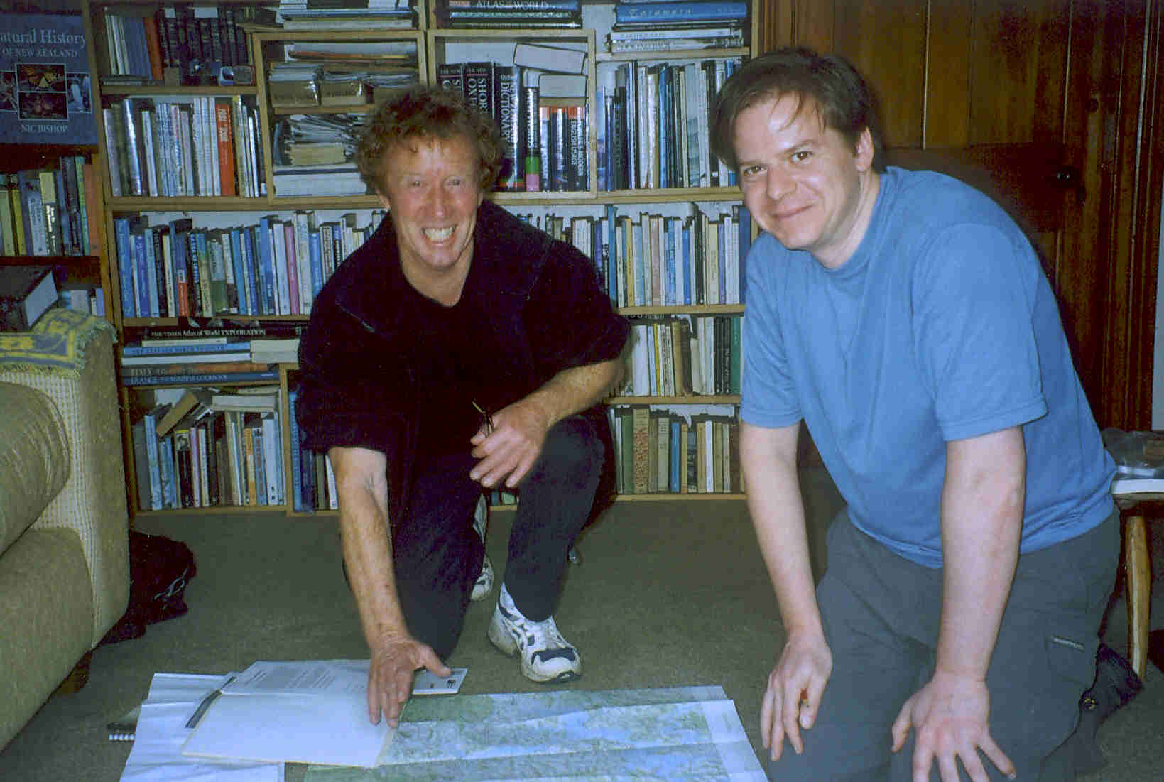 |
Geoff Chapple and Eric Martinot reviewing trail maps Oct. 12 in Auckland before the start of the trek |
Page updated July 4, 2006